  The fortress city
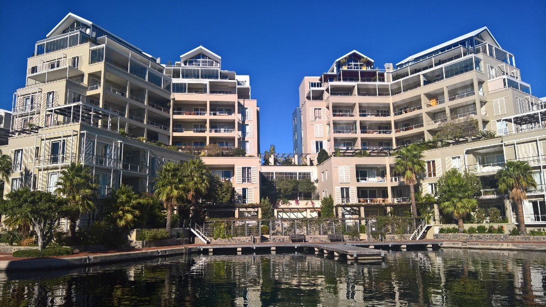
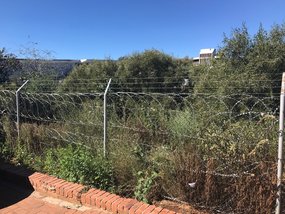
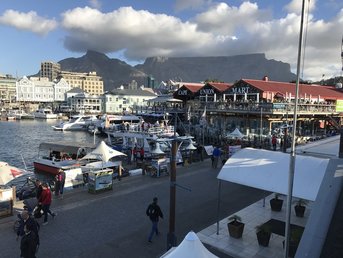
Our visit to Cape Town and Bloemfontein in April 2017 was my first time in sub-Saharan Africa. It was a fascinating trip and we were made very welcome by our South African collaborators. I was left, however, with an acute sense of dislocation, driven in part by this being my first experience of a country in the Global South. A lot of UK academics are now heading to ODA (‘official development assistance’) countries, driven by a shift in funding streams. This means that many scholars who are not development experts are finding themselves confronted for the first time by the complex challenges of the Global South. Because of its unique history, South Africa is a fascinating case study of extreme wealth coexisting with dire poverty. On our first morning, we walked around the beautiful V&A waterfront development in Cape Town and the UK team found themselves making comparisons to similar schemes around the world – including, of course, Birmingham’s BrindleyPlace. The comparison that struck me more, however, was from my visit to Los Angeles in 2013. In City of Quartz (1990), Mike Davis used LA to examine acute segregation within cities (rich, poor, black, white). I’d found LA to be a very uncomfortable place to visit – islands of loveliness surrounded by seas of poverty. Of course, those pleasant parts of LA came at a price – gating, pricing and other mechanisms of restricting entry. In that early work by Davis, LA was very much the archetypal fortress city, showing the future of a planet where the gaps between rich and poor were growing, not shrinking. My crude impression of South Africa from our very brief visit, was that cities like Cape Town and Bloemfontein are an even more extreme version of Davis’ LA. It was never going to be a quick process undoing the legacy of apartheid but more than two decades on, separation is an inescapable reality of everyday life. Visiting some of the townships and seeing the vast numbers of people living in shacks a short distance from Table Mountain and the CBD was shocking. One of the most striking images for me was the razorwire fencing surrounding the University of the Free State campus at Bloemfontein. For sure, UK university campuses have security measures, but the symbolism of “everything past this line is a threat” was striking. Now of course this securitisation of space is so shocking to outsiders because it operates at such a small scale – wealth and poverty in close proximity. Visit Calais, however, and you see the 15-foot high razorwire fences around the Channel tunnel, designed to keep the desperately poor from sub-Saharan Africa out of the UK. Life back home is just as dependent on fortification to keep out the global poor, it’s just that on a day-to-day basis we don’t actually see the bars on our cage.
1 Comment
 Note - this reflective piece is part of a series of blog posts written further to the visit of the UK Team to South Africa in April
Contrasts and opportunities It is common knowledge that the post-apartheid period in South Africa led to a succession of large-scale regeneration projects buoyed by increasingly confident investors and developers. On the one hand, walking through Cape Town’s V&A Waterfront development, for example, replete with its bars, restaurants and cafes serves as a powerful reminder of the benefits of regeneration and placemaking: it is space that contains vitality, movement, and a range of different sights, sounds and smells. At the same time, though, this space bears many of the hallmark features of other large-scale urban regeneration projects. Clearly, as with other cities across the world, the design and overall ambience of the waterfront area reflect official attempts to control contemporary risks of crime and disorder, and enhance the quality of life of certain urban dwellers. In this sense, the area is also imbued with a particular set of socio-cultural values that support economic gain, consumerism and tourism. Cape Town also continues to attract large numbers of people looking to benefit from the recent redevelopment initiatives and projects like the V&A Waterfront create much-needed employment opportunities for those looking to move to the city. Hence “informal” dwellings appear in townships like Khayelitsha and Langa; these settlements accommodate people migrating to Cape Town from the Eastern Cape and from other parts of Africa. The contrast between the regenerated V&A Waterfront and the townships is very stark. After visiting some of these settlements, you can not only begin to appreciate some of the housing, education, employment and other land use challenges facing planners, but also the many different social, cultural, structural, and legal contexts in which “informality” plays out across the townships. Amid a climate of political corruption in South Africa, there have been recent well-documented displays of public outcry over the slow pace of change since the end of apartheid. Clearly, many challenges lie ahead. But there is hope. Visiting “unplanned” Langa, for example, allowed me to appreciate the kind of alternative practices and “different” modes of governance that, in their different ways, give the area so much of its life, colour and vitality. This point resonates with wider debates, of course. Perhaps most fundamentally, visiting the informal settlements reminded me that further and urgent lessons can be learned from exploring the kind of experimental and resilient modes of urban governance that have emerged in different parts of the world in response to a range of economic, social and environmental challenges. Spatial planning, as many theorists and practitioners would attest, can also play an important role in helping to address some of these challenges. Planning education also has a role here, of course, and future planners will have to find ways to wrestles with the issues of urbanisation, informal settlements, poverty, spatial and environmental justice. The recent adoption of Spatial Planning and Land Use Management Act (Act 16 of 2013) (adopted in 2015) presents an excellent opportunity to learn the lessons of the past, and help create integrated spheres of governance that deliver better land use decisions and manage the different changes facing society. Our Linkedin account SAPER project gathering a range of planning practitioners is up and running. Please connect if you'd like to join our future discussions!
We look forward to sharing with you! www.linkedin.com/in/dr-lauren-andres-saper-project-10882b137/ Two new researchers have now joined the team, Rouvé Bingle and Mischka Jacobus, both prospective PhD students. Rouvé and Mischka will assist the South African team all along the project.
Rouvé holds an undergraduate degree in Agriculture (University of Stellenbosch), an Honours degree in Spatial Planning and a Master’s degree in Urban and Regional Planning (both from the University of the Free State. Her main areas of interest include food systems planning,food and nutrition security and urban agriculture. She is further interested in the topics of urban greening, environmental justice, environmental racism and place making. Most recently she worked as a National Research Foundation research assistants at the University of the Free State. Mischka holds an undergraduate degree in Geography and Environmental Management, an Honours degree in Spatial Planning and a Master’s degree in Urban and Regional Planning. Her interests lie in alternative land use management systems for low income areas, geographic information systems (GIS), economic planning and environmental management. She was former research assistant in the Department of Urban and Regional Planning at the University of the Free State and has undertaken various research projects where she held the responsibility of data management and analysis. The UK Team is very pleased to announce that Dr. Lorena Melgaço has now joined the team as research fellow. Lorena is an architect and urban planner trained in Brazil, Germany and France. She was previously a research assistant at the University of Plymouth. Her fields of interest include bottom-bottom spatial practices, in other words the understanding of forms of local agency within a global structure and their relation to the production of space as well as the temporary uses of spaces and the interaction between space, communities and technology in urban and rural spaces. Lorena is also interested in planning perspectives from the Global South and in ways this challenges traditional urban planning theories. Lorena will be based in Birmingham (UK) but will spend a significant amount of time in South Africa. Lauren Andres, 7 February 2017  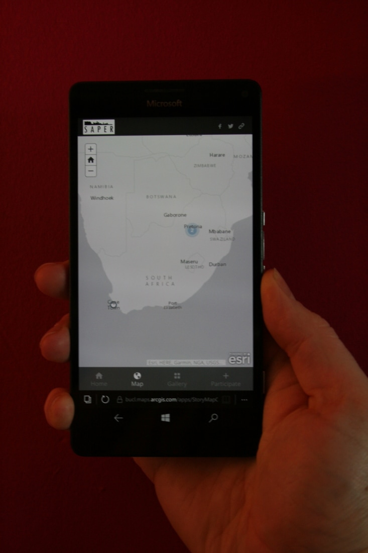 I have two main roles on this project. First to be techie and second to be the voice of wisdom and experience when Lauren is doing battle with our institutional bureaucracy. For discretion's sake, I probably won't talk too much about that second role online, but buy me a coffee sometime and I'll spill the beans.
The UK team will be visiting South Africa in April 2017 for initial meetings with our collaborators as well as with students and planners. I'll be doing some filming while we're out there, which should show up as a short documentary setting out the parameters of the project and the challenges being examined. The more significant of my techie inputs is in thinking through a collaborative platform for sharing information and ideas about planning and regeneration in South Africa. In order to start a conversation about what that platform might look like, I've set up a demonstrator webapp, which is accessible through the 'collaborate' link on our website. Essentially this is a tool which can be used on web/tablet/mobile to allow anyone to add photographs and text to an online map. It thus gives contributors a chance to highlight interesting planning and regeneration projects in South Africa, from which other people may not have been aware of, thus creating a map-based archive. The app allows you to either use the GPS from your device, or simply drag your photo to the relevant location on the map and is - in our testing - pretty easy to use. The map works on any device that has a web browser - even my terrible Windows-based phone that you can see in the photo above. For those interested in technical details, it's built on the ArcGIS Online platform, specifically their Crowdsourced Story Map app, which allows us to easily examine the data gathered within a standard GIS. Depending on how people use it and the kinds of functionality they're interested in, we may look to commission a real programmer to design something more professional-looking. In the meantime, if you happen to be based in South Africa and have an interesting project to share, why not have a go. Phil Jones, University of Birmingham, February 2017 |
AuthorThe SAPER blog is written by different members of the SAPER project team. Archives
March 2020
Categories |
 RSS Feed